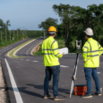
Digital Innovations in Land Surveying
Imagine surveying land like they did in the old days- trekking through fields with a compass …
Products


“Before using CAPZO , our land development projects were plagued by miscommunication and delays. The software’s user management features and automated task scheduling have been a game-changer.”

CEO
“The integrated weather forecasting in CAPZO has been a lifesaver! We can now plan our land surveys and development activities with real-time weather data, minimizing weather-related delays.”

CEO
“As our land development business grew, managing client communication and project documentation became a challenge. CAPZO’s user-friendly interface and collaborative features.”

CEO
” I’ve used numerous tools to manage my services. However, CAPZO has truly transformed the way I operate. The dashboard allows me to oversee all my projects in one place.”

CEO

Imagine surveying land like they did in the old days- trekking through fields with a compass …

The world of land surveying might seem like a complex web of instruments and calculations..

Have you ever wondered how those precise property lines get established, or how engineers..

Ever wondered how those incredibly detailed 3D maps and models you see in movies are made? ..